2023 (JGR) https://doi.org/10.1029/2022JE007279
L. Trompet, A.C. Vandaele, I. Thomas, S. Aoki, F. Daerden, J. Erwin, Z. Flimon, A. Mahieux, L. Neary, S. Robert, G. Villanueva, G. Liuzzi, Lopez Valverde, A. Brines, G. Bellucci, J. J. Lopez-Moreno, M. R. Patel
The Solar Occultation (SO) channel of the Nadir and Occultation for Mars Discovery (NOMAD) instrument scans the Martian atmosphere since 21 April 2018. In this work, we present a subset of the NOMAD SO data measured at the mesosphere. We focused on a spectral range that started to be recorded in Martian Year (MY) 35. A total of 968 vertical profiles of carbon dioxide density and temperature covering MY 35 and the beginning of MY 36 are investigated until 135° of solar longitude. We compared 47 profiles with co-located profiles of Mars Climate Sounder onboard Mars Reconnaissance Orbiter. Most profiles show a good agreement as SO temperatures are only 1.8 K higher but some biases lead to an average absolute difference of 7.4°K. The SO dataset is also compared with simulations from GEM-Mars general circulation model. Both datasets are in good agreement except for the presence of a cold layer in the winter hemisphere and a warm layer at dawn in the Northern hemisphere for solar longitudes between 240° to 360°. Five profiles contain temperatures lower than the limit for CO2 condensation. Strong warm layers are found in 13.5% of the profiles. They are present mainly at dawn and in the winter hemisphere while the Northern dusks appear featureless. The dataset mainly covers high latitudes around 60° and we derived some non-migrating tides. In the Southern winter hemisphere, we derived apparent zonal wavenumber-1 and wavenumber-3 tidal components with a maximum amplitude of 10% and 5% at 63 km, respectively.
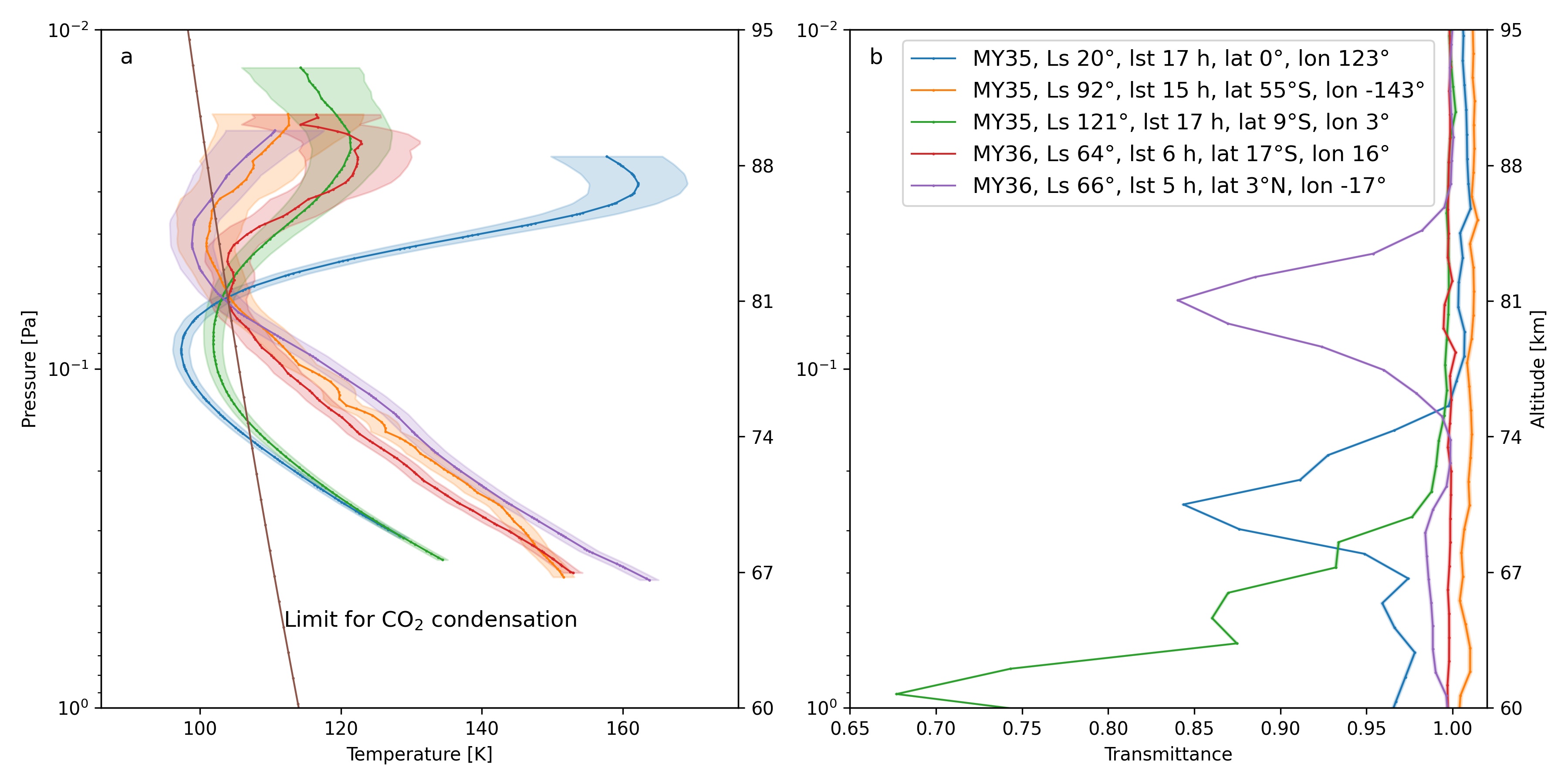
Panel a) six temperature profiles for diffraction order 148 with some values lower than the temperature limit for CO2
condensation. Panel b) transmittances at pixel 180 corresponding to the profiles in panel a. The second Y-axis provides rough
altitude values.